News archive

AVVISO DI PROCEDURA COMPARATIVA PER L’INDIVIDUAZIONE DI UN COLLABORATORE ESTERNO PER ANALISI SATELLITARI E DI DATI DA SMARTCAMERA PER IL MONITORAGGIO FLUVIALE- 5 mesi- Prof. Bizzi

Pubblicazione all'Albo di Ateneo dal 24/11/2025 al 02/12/2025

Dal 24.11.2025 al 02.12.2025

Leggi

AVVISO DI PROCEDURA COMPARATIVA PER L’INDIVIDUAZIONE DI UN COLLABORATORE ESTERNO PER ANALISI SATELLITARI E DI DATI DA SMARTCAMERA PER IL MONITORAGGIO FLUVIALE -2 mesi. Prof. Bizzi

Pubblicazione all'Albo di ateneo dal 24/11/2025 al 02/12/2025

Dal 24.11.2025 al 02.12.2025

Leggi

Seminario di "Avvio al Lavoro" - Approccio progettuale per opere di difesa da caduta massi

Relatore: Dott. Geol Giorgio Giacchetti - Presidente dell'Ordine dei Geologi del Veneto | Giovedì 20 Novembre 2025 | ore 16,30 - Aula Arduino

20.11.2025

I geologi sono i progettisti principali delle barriere paramassi, ma devono conoscere la logica di progettazione.Il seminario (che avrà luogo in lingua italiana) introduce l’approccio progettuale proposto dallo standard UNI 11211:4-2018, che è stato implementato anche da alcuni popolari programmi di

Leggi

Seminario - How excavation activity is both a blessing and a curse for the paleontological heritage: the case study of the fossils from the “lastame” in the Verona province (Northern Italy)

Relatore: Pietro Calzoni - Dipartimento di Geoscienze - Università di Padova | Lunedì 17 Novembre 2025 | ore 16,30 - Aula Arduino

17.11.2025

Among cultural heritage, fossils are one of the most “neglected” goods, especially in Italy, both for unawareness by the public and for economic 
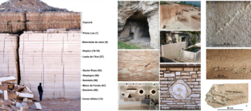
interests due to excavation activity.The Cretaceous sedimentary rocks of the Lessini Mountains, especially the “lastame” stone quarries of the surroundings

Leggi

Seminario di "Avvio al lavoro" - Ground-based radar interferometry. Principles, applications and future development

Relatore: Dott. Alberto Michelini - I.D.S. GeoRadar S.r.l. | Giovedì 13 Novembre 2025 | ore 16,30 - Aula Arduino

13.11.2025

Ground-based radar interferometry (GBRI) is a remote sensing imaging technique based on coherent radar systems, which can measure not only the amplitude, but also the phase of the microwave signals. The phase measurements can then be exploited to derive information on the deformation and topography

Leggi